The Phillips Recreation Center is at 505 W. Stoughton in Urbana. This is at the north-west corner of Springfield and McCullough Streets. If you are coming from out-of-town take the Lincoln Avenue exit from I-74. Head south on Lincoln about a mile to Springfield Avenue (light at intersection). Turn left (which will be heading east toward Urbana). Proceed about 3 blocks -- the Phillips Center will be on your left at the corner of Springfield and McCullough Streets. Free parking is available in the parking lot on the west side of the building. The entrance is on the north side of the building on Stoughton.
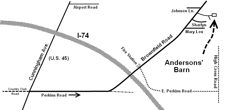
The barn at Tom and Kathy Anderson's home, 2206 N. Brownfield Rd. Urbana
Come toward Champaign-Urbana and get on I-74 heading toward Urbana.
Take the Cunningham Avenue exit to the south (toward town). Turn east at the intersection of Cunningham Rd. and Perkins Rd. Brownfield Rd. curves to the north about 2/3 of a mile east of Cunningham Rd. It then crosses I-74 and the Anderson's is on the right about 1/2 a mile after crossing the highway.
Their phone number is 217-344-6802.
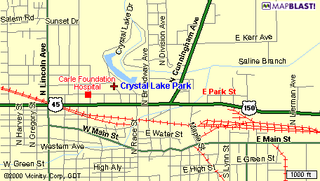
Come toward Champaign-Urbana and get on I-74 heading toward Urbana.
If you are coming from the west, take the Lincoln Avenue exit to the south (toward town). Proceed down Lincoln about a mile to University Avenue (light at intersection). Turn left (which will be heading east toward Urbana). Proceed past Carle Hospital to Lake Street (by the Hardees), turn left (north).
If you are coming from the east, take the Cunningham Avenue exit to the south (toward town). Proceed down Cunningham about a mile to University Avenue (light at intersection). Turn right (west). Proceed through 2 lights to Lake Street (by the Hardees), turn right (north).
Lake Street will take you into the park, the parking lot and pavilion will be on the right.
The Illini Student Union is at 1401 W. Green in Urbana, IL. This is on the south side of Green between Mathews and Wright. The most direct way to get there is to enter Urbana on the Lincoln St. exit from I-74, drive south to Green and then drive west about 4 blocks. Park on Mathews street or in the parking garage one block west of the Union at Sixth and John.
The Channing-Murray Foundation is at 1209 W. Oregon in Urbana, IL. This is at the south-east corner of Oregon and Mathews. The most direct way to get there is to enter Urbana on the Lincoln St. exit from I-74, drive south to Oregon and then drive west to where it deadends at Mathews. Park on the street or in the parking lot across the street on Mathews. Mathews is one-way going south and Oregon is one-way going west.
Take I-72 (not I-74) to Monticello. Exit at the eastern exit for Monticello (Exit 166, marked "Market St. - IL 105"). Take Market St./IL 105 through two stop LIGHTS to the first stop SIGN (corner with the ugly County Market). Turn right onto Marion St., and go to the end (a "T" intersection by a golf course). Turn left onto Allerton Road, and go about 3 miles, past Allerton Park, to another "T". Turn right onto 1300 North Rd. and look for the Kalyx Center sign after about 3/4 mile on the right side of the road. If you get lost or just want more information, call Bill Taylor at 217-762-9561 or try my cell no. 217-649-9085, though I may be out of range.